Prepared by Tom Mastin PLS
Horizontal Datums
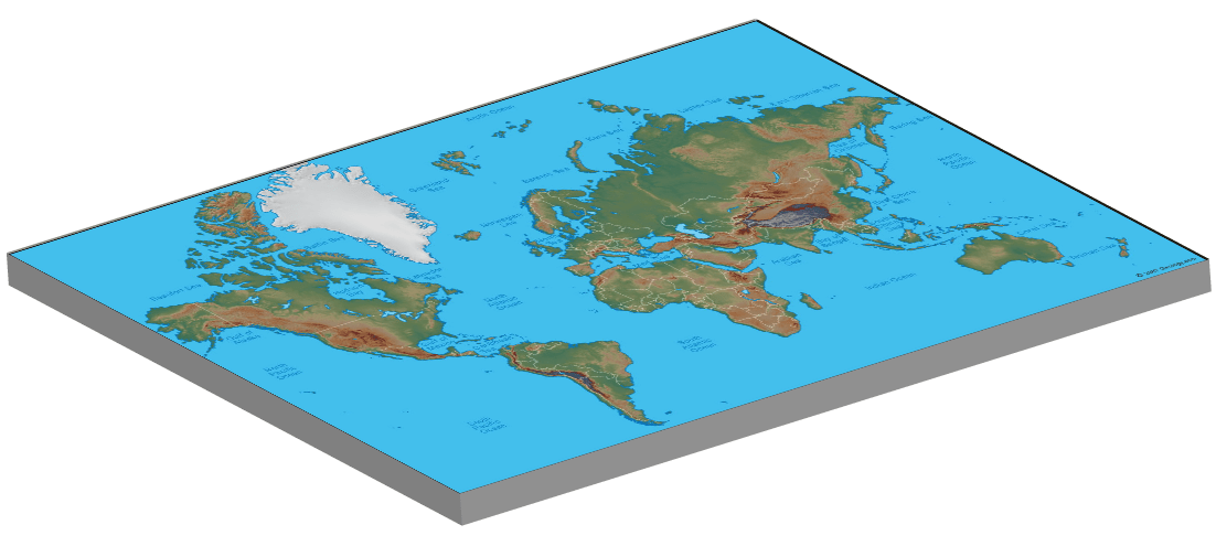

In today’s world there is a need to understand datums. Before we talk about datums, we need to talk about the world we live in. First we need to understand that the world is not flat, although we often think of it that way when we are surveying. Next we need to know that the earth is not a ball, and finally we need to understand that it is not a solid mass. The earth is an irregular shaped mass that is constantly changing due to exterior and interior forces. Once you appreciate that, you can move on to understanding datums and their limitations. When talking about datums it is important to understand there are local, regional and global datums.
A horizontal datum is a basic three dimensional mathematical model of the shape of the earth at some surface, that is physically attached to a monument network. The current math model used is an ablate ellipsoid, which can be thought of as an ellipse spun about the minor axis. The radius to the poles is a bit shorter than the radius to the equator in these models. The values given for an ellipsoid are the Semi Major Axis, which is a distance from the center to the surface of the ellipsoid along the major axis, the Semi Minor Axis which is the distance from the center to the surface along the minor axis, the flattening of an ellipse which is a unit-less value and is calculated using the formula 

There are hundreds, if not thousands of horizontal datums, but there are only a few that you need to know for land surveying in California. First there is the datum that is currently used for the national civilian control, which is North American Datum of 1983 (NAD83), this datum superseded North American Datum of 1927 (NAD27) and although it is dated in 1983 it was completed in 1986 and it was not fully integrated into control surveys until the mid 1990’s. The next datum you should be aware of is World Geodetic System of 1984 ( WGS84) which is the military based datum used by the GPS navigation system. Finally there is an international datum that you will here about; International Terrestrial Reference Frame (ITRF) which currently has a 2014 realization (ITRF2014). Finally you will see IGS datum which is basically the ITRF datum based on the GPS measurements only.
For our discussion here we will focus on NAD83, as it is the datum that is codified into law in California. There are a number of good resources to discuss datums in general and a good place to get started is at the NGS webpage, “What is a Datum?“.
NAD83
NAD83 was developed because advancements in measurement allowed for a more precise measurement of the shape of the earth. While it’s predecessor NAD27 was designed to fit North America well, it did not do a good job of fitting the rest of the world. NAD27 was clearly a regional datum, but with the advent of satellites and other long range measurement techniques a datum that was global was needed. Where as NAD27 was oriented to the earth by tying the model to a control monument “Waldo” in Kansas, NAD83 tied the center of the model to the center of the Earth. So although NAD83 is designed as a global datum, it is fixed to the North American tectonic Plate, so it some sense it is more regional than global.
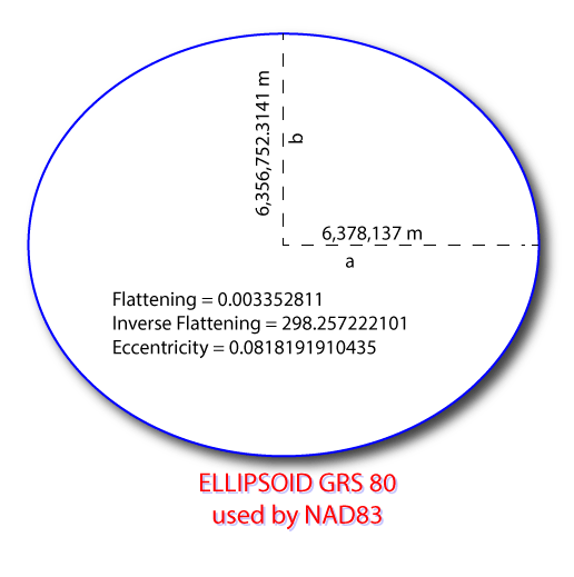
NAD83 uses the GRS80 Ellipsoid, where as mentioned before is tied to the center of the earth. The coordinate system of NAD83 is defined as an Earth Centered,.Earth fixed Cartesian coordinate system. The center of the ellipsoid is the point of origin (0,0,0). The x axis is defined by a line going from the origin to 0° latitude and 0° Longitude, which can be generally thought of as where the prime meridian intersects the equator. The Y axis is 90° to the left along the equator and the Z axis is 90° along the prime meridian. So when you look at these values of a control point in north america, the X and Y values will be negative. However, we more commonly look at the position in terms of latitude (angle from the equator), longitude (angle from the prime meridian), and ellipsoidal height (perpendicular distance from ellipsoid surface). More commonly in land surveying we look at the position based on State Plane Coordinates (See paper on State Plane Coordinates).
Realizations of NAD83
As mentioned before the shape of the earth is continually changing, and in addition the quality of our measurements increases with advancements in technology. There are two parts to a datum, the ellipsoid and the physical network of monuments to fix the ellipsoid to the earth. So what happens over time is the physical network of monuments positions change. This is resolved by adjusting those positions, which they call the adjustments new “realizations” of the same datum.
The original realization of NAD83 was not published until 1986, which provided the original coordinate values for the network. Those values were all based on what is called classical measurements (Distances and angles). In the time frame of 1983 to 1986 GPS was being developed as a measurement system for civilian use. It became clear that over long distances, GPS provided more precise positions, in fact the longer the distance the more impressive the quality of GPS positioning. This prompted National Geodetic Survey (NGS), the agency responsible for NAD83 to pursue its first major adjustment.
HARN
NGS convinced all the states that they should establish a GPS controlled monument network within their state that would be combined with all the other states and then NGS would perform an adjustment of the NAD83 values. Because GPS did not require visibility between control monuments, much of the previous control, which often was on mountain tops, were not included in this survey. In fact, because in most states the agency that took responsibility for this survey was the highway departments, most of the monuments for this survey can be found along monuments. So the plus was that there was easy access to these monuments, and the minus was that many were within freeway right of ways that required permits to access.NGS called this project the High Accuracy Reference Network (HARN) and instructed the states to call it the same.
In California (and a couple of other states) they called the project the High Precision Geodetic Network (HPGN). Caltrans managed the project and originally established monuments at approximately a 50 km spacing along their right of ways, which later on they densified to about 10 km spacing. The process was completed in early 1990’s in California and NGS completed their adjustment soon thereafter. One of the problems that was starting to be understood with using GPS, was that it did not take a very long time before you could measure the change in position of a monument due to earth movement. Therefore they needed to set a date to these positions, and that date (epoch) was 1991.35. That is the coordinates were good for the day that is .35 of a year in 1991. That is somewhere around May 5 or 6 in 1991. Just to make matters more confusing often they call this realization 1992. So what you began to see when working with NAD83 coordinates in various software packages, you could see this realization listed as either HARN, HPGN, 1991.35 or 1992. All the same realization, just different ways to label it.
CORS 96
The next major realization was called CORS 96.My understanding of the reasoning for this realization was because, although they were using very precise measurements in the HARN adjustment, the network adjustment itself was not done as rigorously as it should have. A general rule for network adjustments is create an exterior framework and from there build the interior. This keeps errors contained within that exterior framework. However with HARN they basically built each state and then tied to the adjoining states. They did not have a rigorous exterior frame.
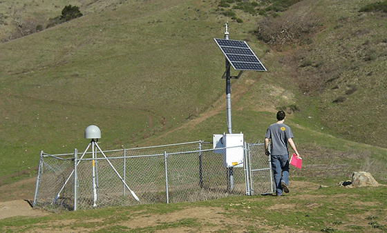
This was resolved by creating an exterior from the Continuously Operating Reference Stations (CORS) which were GPS stations that were always running. NGS was establishing these across the United States The CORS stations gave a strong exterior network and allowed the state data to be combined into a stronger interior network.
NSRS2007
There were some minor and not so minor adjustments between CORS 96 and NSRS2007, but NSRS2007 was the next major realization. This realization took a longer time to come about, but tin that time they developed a more systematic process for these realizations. NSRS stands for National Spatial Reference System, which was to be used whenever referencing this realization. However the more important realization was that their database of control could not handle 8 characters for the realization, so you will just see it as 2007.
A couple of important points about this adjustment. First although there were some improvements in the measurement and adjustment process, mostly it is showing the changing shape of the earth across North America. Second, they formalized this idea that the coordinate values are good for a specific date. They define that date as an epoch, and set the epoch for 2007 as January 1, 2005 or as they call it 2005.00.
2011
The current Realization (as of this writing) is 2011. The epoch for 2011 is January 1, 2010 or 2010.00.
How important are realizations
The importance of realizations is based on the needed precision of a position and where you are in North America. If you are on the North American Plate you will see smaller changes than if you are on say the Pacific Plate. To get an idea of the changes, I looked at the values for various realizations at two locations. One in Kansas, and one on the Pacific Plate on the west coast. I also showed the relative shift from NAD27 just for comparison.
Meades Ranch Reset
| Realization | Latitude (d m s.ss) | Longitude (d m s.ss) | shift north from 2011 | shift east from 2011 |
|---|---|---|---|---|
| NAD 83 - 2011 | 39 13 26.71220 | 098 32 31.74540 | 0.00' | 0.00' |
| NAD 83 - 2007 | 39 13 26.71218 | 098 32 31.74604 | -0.00' | -0.05' |
| NAD83 - CORS96 | 39 13 26.71169 | 098 32 31.74579 | -0.05' | -0.03' |
| NAD83 -1986 | 39 13 26.71982 | 098 32 31.74686 | +0.77' | -0.11' |
| NAD 27 | 39 13 26.68600 | 098 32 30.50600 | +2.65' | +97.54' |
Monterey
| Realization | Latitude (ddd mm s.ss) | Longitude (dddd mm s.ss) | shift north from 2011 | shift east from 2011 |
|---|---|---|---|---|
| NAD 83 - 2011 | 35-17-37.70588 | 120-38-44.37687 | 0.00' | 0.00' |
| NAD 83 - 2007 | 35 17 37.70262 | 120 38 44.37447 | -0.33' | +0.21' |
| NAD83 - HPGN | 35 17 37.68346 | 120 38 44.35564 | -2.26' | +1.83' |
| NAD83 -1986 | 35 17 37.67867 | 120 38 44.34635 | -2.75' | +2.62' |
| NAD 27 | 35 17 37.76855 | 120 38 40.72601 | +6.33' | +314.0 |
How to work with epochs
How do you base a control survey on the 2011 realization if you didn’t happen to do all your surveying on January 1, 2010. Well what you need to do is to either move your coordinates to the position they would have been on January 1, 2010 or move the control coordinates to the current position. Currently the best way to do this is to use a NGS app, HTDP. HTDP stands for Horizontal Time-Dependent Positioning and can be run on line or you can download the program to run on a PC. This program will perform a number of tasks, but for surveying what it does best is determine the shift of a position between time staying within the same realization. It can do realization transformations, but it is not as rigorous as GEOCON, another NGS app. HTDP really deals with movement due to change in time.
The next question is should you move control to your date or your survey to the realization epoch. There is no hard and fast rule, however, moving everything to the published epoch, allows easy comparison to other control.
Projections
A projection is a two dimension model of a 3 dimensional surface. Think of a datum as a globe and a projection as a map. The reason for projections, is that it allows the use of a Cartesian coordinate system that is easy to work with. The process of determining the direction and distance based on latitude and longitude values is complex, where as determining the distance and direction based on an X,Y positions is very simple.
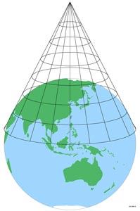
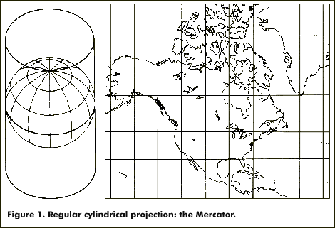
There are a number of ways to flatten a 3 dimensional surface, two common ways are to place a cone over the surface, project the surface onto the cone and then unroll the cone. Another way is to take a cylinder and wrap it around the earth, project the surface and then unwrap it. Again, these are not the only methods but they are common methods.
So the question might come up as to why do we use datums at all, why not just projections. While, first we need to have a datum to project and more importantly any projection has distortions associated with it. It is not practical to have a single projection for the earth for anything other than a wall map because the distortions are so large. Different projections have different types of distortions. A conformal projection will maintain the shape, but scale will change, which means area will be distorted. There are equal-area projections, which will maintain area ratios, but shape will be distorted.
There are many good books and web-sites devoted to projections, but I have found a good basic web site about projections is on the Geographers Craft site from University of Colorado at Boulder. Click here to visit the site.
In order to work with projections and maintain any sort of precision, a projection system is created. These systems consist of a datum and a series of projections. A single projection only covers a small part of the datum. The area covered by a single projection is controlled by the desired precision in the distortion. The Military has a Universal Transverse Mercator (UTM) system where each projection or zone covers 6° Longitude. The distortion of this systems is 1 / 2500 or better. That means that for every 2500 feet you travel along one of the projections, you could have up to 1 foot of distortion. This is way too large of an error for any surveying so surveyors do not generally work in in UTM. Instead surveyors in the United States use what are called State Plane Coordinates which have a distortion of 1 / 100,000 or better. Please read the area on State Plane Coordinates